Climate change as part of the new methodology for the development of the Spatial Plan of the RNM
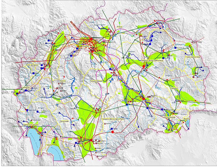
As a document of highest national importance, the Spatial Plan is a strategic, long-term, integral, and developmental document that deals with the organization, protection and management of a country’s territory - a limited national treasure of special value. The Spatial Plan of a country is based on the sector-specific strategies on particular segments of development as well as on all documents of national scope, and it completely relies, from a methodological point of view, on the doctrine of sustainable development, which gives it the full right to receive the epithet and the weight of a strategy on the spatial development of the country. It has a long-term scope and is based on the principles of flexibility and adaptability to the development-related processes and structural changes that are bound to happen. This emphasizes the fact that the Plan is a process and that it needs to actively and constantly adapt to solutions offered by planners, as well as the need for finding optimal options for preservation of the integrity of the space and the quality thereof.

We spoke about the new methodology that integrates climate change in the Spatial Plan of RNM with Mr. Nebi Rexhepi, Head of the Spatial Planning Department in MoEPP, and with Mr. Dejan Gadzovski, Advisor in MoEPP on spatial plan implementation.
What is the role of the Ministry of Environment and Physical Planning in the development of spatial plans?
The Ministry of Environment and Physical Planning (MoEPP) is the entity ordering, financing and coordinating the development of spatial plans. It works in close cooperation with the Agency for Spatial Planning, which is the actual developer of the Plan.
Given that a number of institutions (ministries, public enterprises, agencies and other institutions that are represented by elected representatives, as well as municipalities represented by their participatory bodies) are involved in the process of development of spatial plans, the MoEPP appoints a coordinator for each spatial plan, tasked with maintaining the communication with the institutions involved in the process. The task of the coordinator is to conduct the entire administrative procedure, from the very beginning of the development of the plan until its adoption, which includes: obtaining the necessary information and documentation; organizing meetings; agreement/memorandum signing; establishing a coordinating body for development of the plan; establishing expert commission for plan audit; and drafting a report on the audit.
Through its coordinator, the MoEPP is involved in the selection of various teams for the development of the special expert reports that constitute the basis for the development of the Plan.
Furthermore, the MoEPP implements a Strategic Environmental Assessment (SEA) procedure as part of the implementation of the Plan. The Ministry issues a report on the SEA and includes it in the final version of the Plan, and organizes public hearings on the draft versions of the Plan and of the SEA Report.
At the end of the entire working process, the key task of MoEPP is to formalize the document by submitting it to the Government for endorsement and eventually to the Assembly of the Republic of North Macedonia where it is necessary to "defend" it in the debates before the relevant committee in the Assembly (Committee for urbanism and environment) and at the plenary session; the Plan becomes valid, legally binding and mandatory for implementation after it has been adopted at the plenary session.
A new methodology for development of the new Spatial Plan is being drafted. What kind of a methodology is it and why was it necessary to make those changes?
The need for a new methodology for development of spatial plans came along with the need to produce a new spatial plan of the country. Considering that the existing methodology is quite old (made for the Spatial Plan of 1982), it does not suit the current conditions and needs of the country. In particular, its "disadvantage" is that it is intended for plans in a different type of society (a socialist one), for a different level of development of the society and different needs of the economy, and it lacks guidelines on measures for dealing with climate change, which is also understandable given that climate change is a phenomenon of newer age.
The idea is to overcome all these shortcomings of the old (existing) methodology by way of developing a new, modern methodology that will create a solid basis for developing new spatial plans, and, above all, give appropriate guidelines for sustainable development and environmental protection as well as guidelines for the very important and urgent measures for adaptation to and mitigation of climate change.
It is extremely important to introduce climate change as a methodological tool through which the foundations for creating spatial strategies, plans and policies will be laid, because ignoring them can lead to a kind of spatial development that will be unable to deal with unpredictable scenarios caused by climate change.
Another important component the new methodology should foresee is the possibility for fast and efficient updating of the plans (which is otherwise a rigid process, bearing in mind the way in which plans are developed and adopted), as well as for easier and more efficient implementation of the spatial plans and the monitoring thereof. Among other things, as a candidate country for EU membership and a signatory of many international treaties and conventions and follower of European spatial development policies, the methodology needs to take into account specific EU directives that have an impact on spatial planning, as well as the European and global trends in the spatial planning policy area.
What is your vision for the new Spatial Plan considering that it is a long term strategy of the country with a planning horizon of twenty years?
The vision for the new spatial plan is for it to be modern, which means to meet today's conditions and needs, but also to be visionary and anticipating all possible future scenarios and possible measures for action and reaction. In addition, it must be adapted to the modern European trends in the field of spatial planning (both as a policy and in practice), but also to be in line with the spatial plans of our neighboring countries.
Modernity means both the use of state-of-the-art technology tools for the production of the Spatial Plan, as well as modern final form of the Plan - digitized, georeferenced, and featuring an adequate database that would be easy to access and update, user friendly and enabling a fast and accurate decision-making as well as easy insight into the implementation of the Plan and its monitoring.
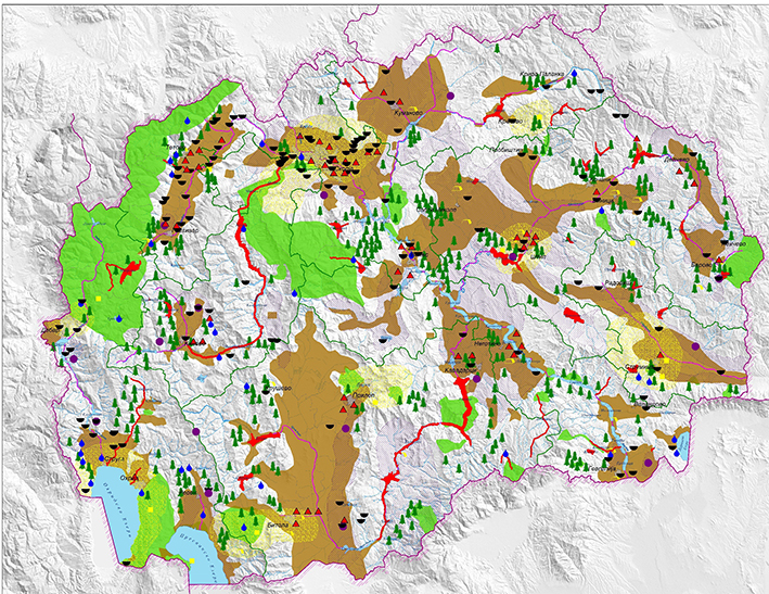
Such a plan should provide a rapid, smooth and appropriate response to the needs of the modern economy and to developmental needs, but only through adequate and sustainable use of natural resources while taking care of the protection of the environment and human health. Therefore, we see the integration of climate change as a possibility for devising a modern methodology since climate change is one of the leading aspects and priorities in the creation of spatial plans and of new regulations and obligations stemming therefrom. This approach is of pioneer’s nature since tackling climate change is hereby introduced into the most powerful state document from a legal point of view, which regulates and manages the entire territory of the country. Finally, a spatial plan developed on the basis of a methodology that has integrated and taken into account all impacts and consequences of climate change will result in spatial planning that protects the environment, strengthens the micro and macro ecology across the country, and provides balanced and adequate urban development while protecting these areas from floods, fires, earthquakes, landslides, lack of goods, etc. It will also see to the conservation of natural resources and the optimal use thereof, and will protect and improve forests, pastures and zones for agricultural development by intervening in places susceptible to droughts and fires and in zones experiencing soil degradation.
Where climate change is a guiding factor when making decision related to spatial planning, one can be sure that the territory of that country will develop sustainably towards harmony with Nature and resilience to unpredictable climate scenarios.
-
Корисни линкови
26-01-2021 -
Справување со климатските промени и загадувањето на воздухот во градот Скопје
29-04-2018 -
Финансирање во климата
28-01-2022 -
Микронаративи
08-06-2022
{{"article.lastestPosts"|translate}}
-
Презентирани сценаријата и мерките за ублажување на климатските промени: одржани национални работилници за финалниот нацрт на БТР1 и NDC 3.0
06-01-2026 -
Клучен исчекор кон поголема климатска транспарентност: одржана национална работилница со широк мултисекторски ангажман
10-12-2025 -
Обраќање на Генералниот Секретар на Обединетите Нации, Н.Е. Антонио Гутереш за нужноста од климатска акција, 10 години после Парискиот договор
10-11-2025 -
Стопанската комора на Северна Македонија го изработи првиот водич за декарбонизација за малите бизниси во земјата
28-10-2025


 Мод за знаковен јазик
 Говорен асистент
 Означи линкови

 Зголеми маус